
At XylemLab, our projects are at the heart of our mission to revolutionize agricultural monitoring and food security across Africa and beyond. Each initiative is designed to merge cutting-edge satellite technology with local expertise, creating innovative, scalable solutions that address real-world challenges. From collaborating with NASA and GEOGLAM to enhance crop monitoring, to working with AGRA and Lacuna Fund to empower local communities with data-driven tools, our projects span the intersection of science, technology, and sustainability. Together with African governments, universities, and global partners, we are building a future where technology and local knowledge combine to drive impactful, sustainable change in agriculture. Explore our projects to see how we’re transforming challenges into opportunities for growth and resilience.

On-Going Research
-
![]()
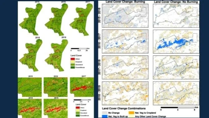
Conflict, Displacement and Landuse
-
![]()
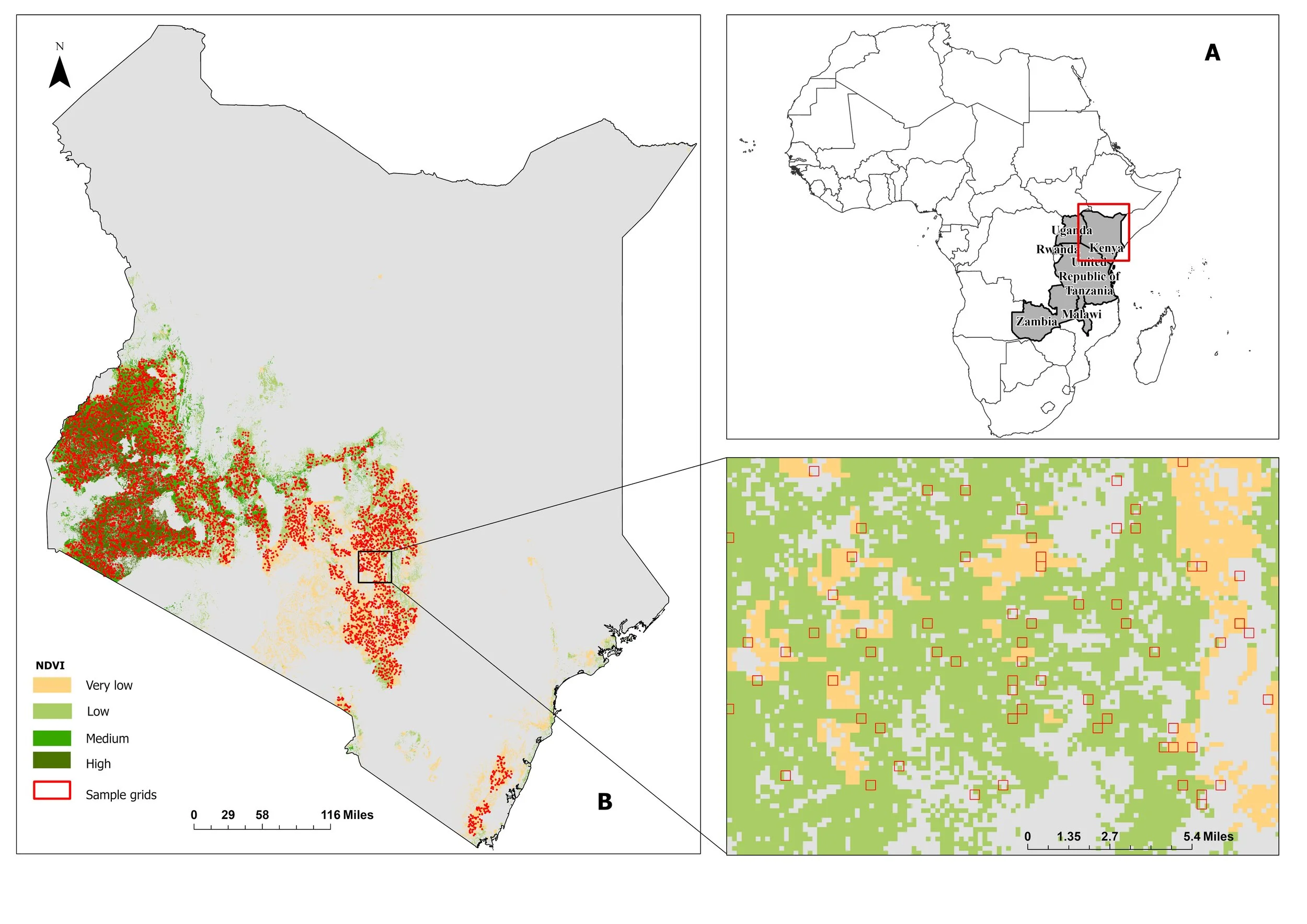
Drought Mapping and Monitoring
-
![]()
Cropland Mapping
-
![]()
Weather Shocks on Dietary Quality
-
![]()
Mapping Extreme Events
-
![]()
Helmets Labeling Crops
-
![]()
Yield and Production Estimation


RECENT FUNDED PROJECTS
-

Regional Food Balance Sheet
Xylem supports the AGRA and COMESA-led Regional Food Balance Sheet (RFBS), which uses data from various public and private sources to develop near real-time and forward-looking food balance estimates. Our team develops crop yield analytics from satellite and historically reported yields to forecast seasonal yields and crop production for RFBS countries.
-

Harvest Africa
The Harvest Africa initiative aims to enhance food security, agricultural productivity, and resilience across Africa by promoting the use of Earth Observation (EO) data among national and regional agencies. This program focuses on strengthening monitoring and early warning systems to deliver actionable agricultural intelligence, refining underlying methodologies, building local capacity for data-driven decision-making, and fostering lasting partnerships. Through these efforts, Harvest Africa works to empower African institutions with the tools and expertise needed to leverage satellite data for improved agricultural outcomes and food security planning.
-
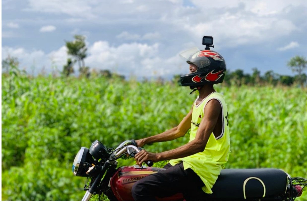
Helmets Labeling Crops
The Helmets Labeling Crops Project (“Helmets” for short)Lacuna Fund- funded by the Lacuna Fund is developing and applying innovative, scalable data collection approaches that can inform machine learning (ML) tools to support higher-frequency crop-type mapping.
-
NASA Harvest
NASA Harvest is NASA’s Food Security and Agriculture Program. Led by the Univerity of Maryland. Harvest's mission is to enable and advance the adoption of satellite Earth observations by public and private organizations to benefit food security, agriculture, and human and environmental resiliency in the US and worldwide. We accomplish this through a multidisciplinary and multisectoral Consortium of leading scientists and agricultural stakeholders, led by researchers at the University of Maryland and implemented with our global partners. Dr. Nakalembe is the Africa Program lead for NASA Harvest.
-

NASA SERVIR
Earth Observations for National Agriculture Monitoring (EO-NAM) for West Africa
Funded by NASA SERVIR and working with CSE Senegal, the main objective of this project is to advance national agriculture monitoring by using Earth Observations (EO) data in East and Southern Africa through the development of in-season semi-automated baseline datasets derived from scalable AI and machine learning tools and open data for more accurate agriculture monitoring.
-

Enabling Crop Analytics at Scale (ECAAS)-Kenya
Developing a Framework for Regional Yield Data Collection, 2023
The second round of work under ECAAS built upon key lessons from Phase-1. Early collaboration with the Ministry of Agriculture ensured program alignment with monitoring needs and sustainable institutionalization. Developing sampling frameworks well in advance guided effective data collection while utilizing county extension agents leveraged their valuable local knowledge and farmer relationships. The UMD team's direct involvement in field training and data collection facilitated skill transfer, and Kenya's approach served as a model for developing sampling frameworks in other focus countries.
-

EO-FARM
Our EO-FARM project, EO-FARM, was funded by the SwissRe Foundation. The project aimed to develop semi-automated, scalable remote sensing-based datasets and information products for maize and wheat conditions and yield assessment.
-

Optimizing Crop Yield Data Collection for Supply Chain Enhancement
Our project collected rice field data in Tanzania with Sokoine University and Flamingoo Food Limited partners. Using ECAAS's Open Data Kit to demonstrate how to optimize data collection while reducing costs for critical agricultural decision-making.
Recent Publications- Refer to Google Scholar for a complete list of all our research publications
-

Rufin P, Meyfroidt P, Akinyemi FO, Estes L, Ibrahim ES, Jain M, Kerner H, Lisboa SN, Lobell D, Nakalembe C, Persello C. To enhance sustainable development goal research, open up commercial satellite image archives. Proceedings of the National Academy of Sciences. 2025 Feb 18;122(7):e2410246122.
-

Catherine Nakalembe, Hannah Kerner, Ivan Zvonkov et al. A Framework for EO-Based National Agricultural Monitoring (EO-NAM)- For the African Context, 06 September 2024, PREPRINT (Version 1) available at Research Square [https://doi.org/10.21203/rs.3.rs-4731424/v1]
-

Nakalembe, Catherine, Taryn Devereux, and Alana Ginsburg. "Whose priorities? examining inequities in Earth observation advancements across Africa." Perspectives of Earth and Space Scientists 5.1 (2024): e2023CN000220.
-

Nakalembe, Catherine, et al. "A 40-year remote sensing analysis of spatiotemporal temperature and rainfall patterns in Senegal." Frontiers in Climate 7 (2025): 1462626.
-

Kebede, E.A., Abou Ali, H., Clavelle, T., Froehlich, H.E., Gephart, J.A., Hartman, S., Herrero, M., Kerner, H., Mehta, P., Nakalembe, C. and Ray, D.K., 2024. Assessing and addressing the global state of food production data scarcity. Nature Reviews Earth & Environment, 5(4), pp.295-311.
-

Kerner H, Nakalembe C, Yang A, Zvonkov I, McWeeny R, Tseng G, Becker-Reshef I. How accurate are existing land cover maps for agriculture in Sub-Saharan Africa?. Scientific Data. 2024 May 10;11(1):486.
-

Kerner, H. R., Nakalembe, C., Yeh, B., Zvonkov, I., Skakun, S., Becker-Reshef, I., & McNally, A. (2024). Satellite data shows resilience of Tigrayan farmers in crop cultivation during civil war. Science of Remote Sensing, 100140.